top of page

It's that time of year again. It's been a little over seven months since I last documented the sandbar changes at Sullivan's Island, Breach Inlet, and south Isle of Palms. Since we recently had king tides again, I flew the drone at a negative low tide to capture some new images.


For those new to seeing this, barrier island sandbars change over time. The sandbars around Breach Inlet are no exception, particularly with all the beach renourishment work that has been going on recently on both Sullivan's Island and Isle of Palms. The relevance to Charleston Ocean Athletes? This area is a big playground for the local ocean athletes and everything surf, wind, paddle, and foil related so it's useful to see where the sandbars are and how they have changed as that affects the waves, chop, and the way tides flow through that area. Hopefully this is also useful to the local boating community.


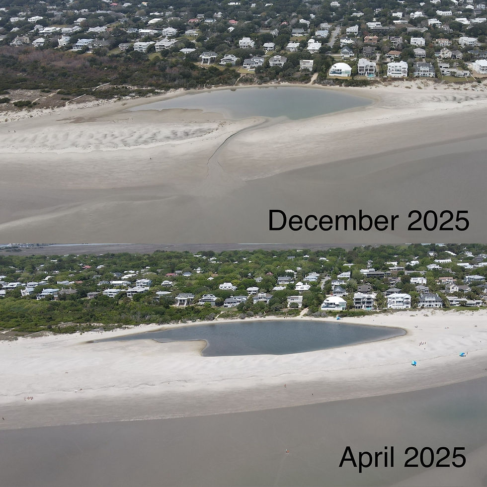
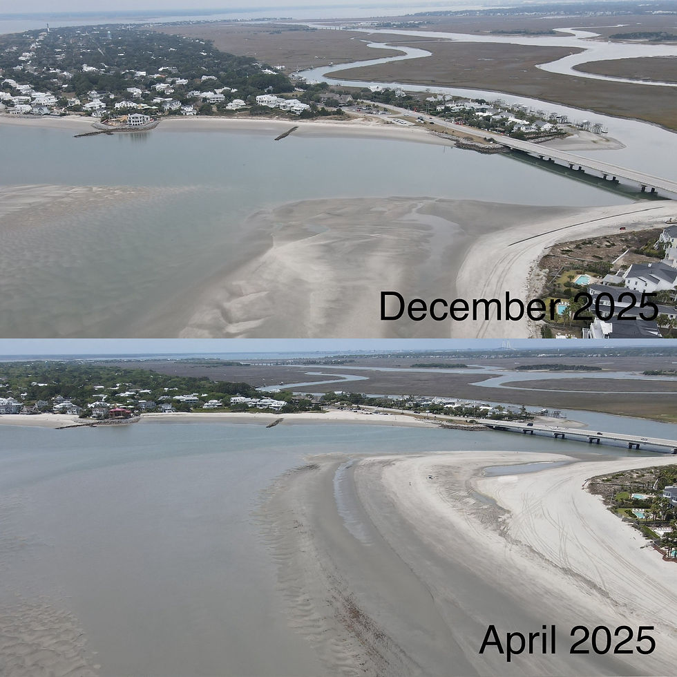
I last documented the changes in late April at dead low tide of -0.5'. I flew the drone again this past Thursday, December 4th at dead low tide of -0.3'. Not quite an exact comparison as I usually try to do, but close enough. It was unfortunately a cloudy day, so please excuse the poor lighting.


Below are some new comparison photos, then more December 2025 photos & video after that.


Breach Inlet - doesn't appear to be any big changes


Station 28.5 - again, no big changes here


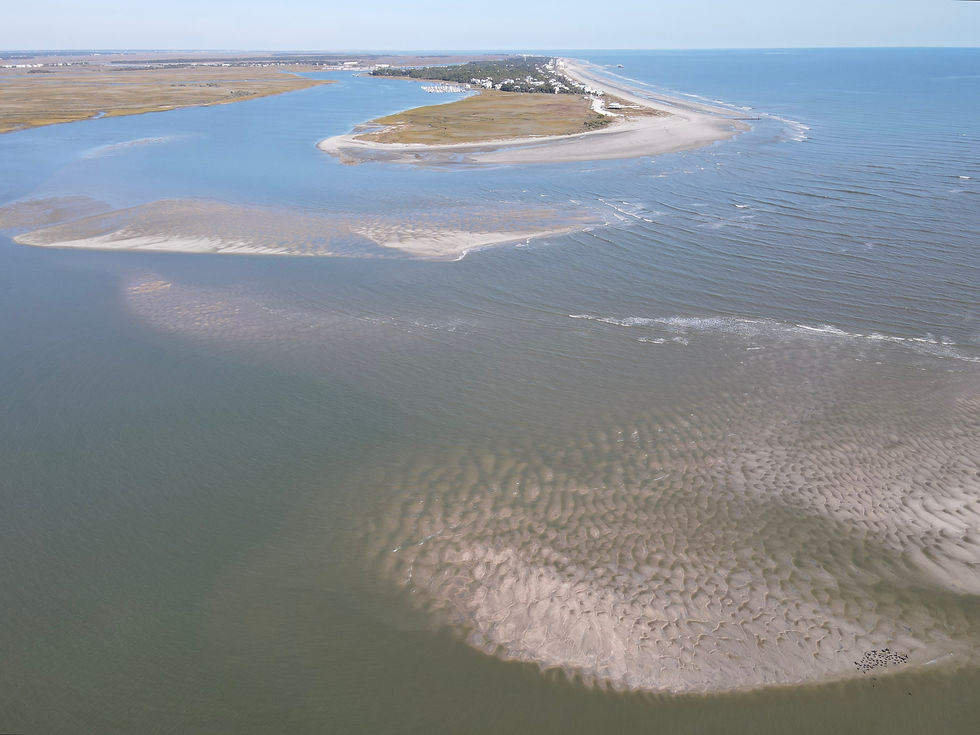
Station 30 - that super shallow area in front of the beach now seems a little bit less so


Looking south towards Station 26 and beyond towards the lighthouse - shifting sandbars here for sure


Same as above, just a slightly different angle from further out


Breach Inlet Bridge & south IOP - a different shape closer to the beach and a large sandbar forming further out (top image, to the left)


Another view, looking north, that new large sandbar off south IOP


A few videos, then more photos...


360 degree view, starting in front of Station 29


Station 28.5 to Station 30


South Isle of Palms


Breach Inlet looking towards the bridge


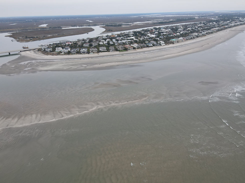
A wider view of the Breach Inlet sandbar along north Sullivan's Island looking towards Isle of Palms


A wider view of Station 28.5


Bird's eye view of Station 28.5


Bird's eye view of the beach at Station 29 looking north towards the bridge


further out from Station 29 & 30, looking towards the bridge


close view of Station 31, looking south


A wider view of outer Breach Inlet, looking south


a closer look at the beach south of Station 28


south end of Isle of Palms


Slightly closer look at south end Isle of Palms


south end of Isle of Palms and Breach Inlet Bridge


Same as above, wider view


A slightly closer look at the south end Isle of Palms beach


south end of Isle of Palms, looking north towards the IOP Pier


Bird's eye view of south Isle of Palms, looking towards Sullivan's Island (note the brand new large sandbags stacked in front of the oceanfront homes here)


Same as above, a slightly different and wide angle looking south towards the outer sandbars


It's been a year since I've documented the sandbars off the south end of Folly Beach. That was October 18th, 2024 during a negative low tide of -0.3'. I went back out on November 5th of this year, again during a negative low tide of -0.3' to capture new aerial images of the sandbars. Below are comparison photos plus many more images from November 5th.


The relevance to Charleston Ocean Athletes? Many play around these sandbars in various wind, surf, foil, and paddle sports so it's useful to know how the sandbars have changed. These sandbars dictate where we have flat water, bump and jump, and wave conditions. Plus, it's just plain interesting to see the changes.


In this case, there doesn't appear to be much discernible differences in the sandbars just off the beach of South Folly, or around Bird Key. Bird Key looks as healthy as ever, much better than two to three years ago. The biggest differences appear to lie in the sandbars between south Folly and Bird Key. It looks like the sandbars have lessened and shifted in that area quite a bit.


Forgive me for some angle differences in the comparison photos below. It's tough to get the exact angle and height as the year before. The angle and height differences can make comparisons difficult to judge accurately but you can get the general idea by looking at them.

The Stono River mouth, Bird Key, and the sandbars north of Bird Key.


Looking south towards Kiawah Island and the east end of Bird Key


This view is just off the south end of Folly Beach facing west towards the Folly River mouth. Bird Key is just out of view to the left.


The south end of Folly Beach - not much discernible difference in the sandbars here


Looking north towards the south end of Folly Beach


Bird Key - not much difference - it looks pretty healthy!


The following are all from November 5th, 2025 at dead low tide of -0.3'


Here is a 360 degree video view of the area on November 5th at dead low tide of -0.3' - the drone was flying between south Folly Beach and Bird Key...


Here is a video of Bird Key...


The following six aerial images are a 180 degree view sweeping from north (towards south Folly), to west (towards Snake Island), to south (towards Kiawah Island)...


Some more individual aerial images of the area...


The Stono River mouth and northwest corner of Bird Key


Same view as above, just zoomed in a bit more. Boaters can hug Bird Key at low tide and get through there to/from Stono River & Folly River just fine it appears as long as you stay far from those sandbars along Snake Island (top right).


northwest corner of Bird Key is at bottom right, looking north up the Folly River, Snake Island to the left


The sandbars between Bird Key and south Folly


same view as above, just slightly to the right (northeast)


Looking east towards the Atlantic Ocean, this is a narrow channel along the north side of Bird Key that leads to breaking waves on a shallow sandbar (Bird Key to the right)


same channel as above, view looking south towards Bird Key and Kiawah Island


eastern tip of Bird Key looking east towards the Atlantic Ocean. Thats the northeastern most tip of Kiawah Island at top right


Bird Key, looking towards northeastern tip of Kiawah Island


Looking southwest towards the Stono River mouth, Bird Key, Snake Island, and the sandbars north of Bird Key


Same view as above, just zoomed in a bit more


Closer view of the sandbars north of Bird Key, looking west towards Snake Island


Bird Key, looking towards Kiawah Island - note the boat's path along Bird Key bypassing those shallow sandbars along Snake Island


Same view, same boat as above - zoomed in just a bit more


same boat as above, making its way into the mouth of the Folly River


It's that time of year again for an update on the Sullivan's Island sandbars. As we all know, the sandbars change naturally over time but this time it's particularly interesting since there has been a great deal of man-made beach renourishment work going on at both the south end of Isle of Palms and the north end of Sullivan's Island. A massive amount of sand has been pumped in to these spots the last several months from the spoil islands along the ICW nearby.


At bottom of this post are some south Isle of Palms photos and videos as well, ending with a 5 minute aerial video collage of Breach Inlet / Isle of Palms / Sullivan's Island.


I flew the drone on Friday, April 25th at dead low tide, which was -0.5' at that time. By comparison, the last time I captured images there, it was also a negative -0.5' low tide on September 18th, 2024. Below are some comparison photos showing the difference in seven months.


For those new to seeing this - the relevance is that this area is a big playground for the local Charleston area ocean athlete community in all things surf, windsport, paddling, and foiling related. It helps to know how the sandbars are changing and where. Hopefully this is helpful to the local boating community as well.


Breach Inlet facing north towards the Breach Inlet Bridge and south end of Isle of Palms

Station 30 - note the new sand from the recent beach renourishment work, particularly how the old rock jetties are now covered up.

Station 28.5
Station 28.5

Facing south towards the lighthouse and harbor entrance

A wider view facing south towards the lighthouse and harbor entrance

360 degree video - it starts facing north over Breach Inlet

A brief clip moving south towards the lighthouse and harbor entrance

A brief clip outside of Station 28.5

Video starting south of Station 28.5 and moving north over the beach towards Station 30

More Photos...


Facing north over Breach Inlet towards Station 30 and the Breach Inlet Bridge

A view of Station 28.5 and Breach Inlet from way outside

Way outside facing south towards the lighthouse and harbor entrance

South of Station 28.5 facing north towards it and Breach Inlet

Over Breach Inlet facing north toward the Breach Inlet Bridge and Isle of Palms

The outer Breach Inlet sandbars on south side of the inlet (facing towards Isle of Palms)

Facing the ocean - the outer Breach Inlet sandbar. This is why you don't drive a boat through there at low tide.

Over Station 30, looking south and outside of Station 28.5. It appears a new inner channel might be forming again inside of Breach Inlet, reminiscent of years' past.

A closer view of Station 30 facing north

North of Station 30, facing south towards Station 28.5

South IOP images....


Outside of south Isle of Palms facing west toward the Breach Inlet Bridge

Outside south Isle of Palms facing 2nd Avenue and north

Video outside south Isle of Palms facing the Breach Inlet Bridge then swinging north towards the pier

South end of Isle of Palms and flying north

South end of Isle of Palms facing north up the beach, note the beach renourishment heavy equipment at 3rd Avenue.

South end of Isle of Palms facing south towards the outer sandbars of Breach Inlet and Sullivan's Island

South end of Isle of Palms facing the Breach inlet Bridge and Sullivan's Island

180 degree video of Breach Inlet at Sullivan's Island & Isle of Palms

5 minute aerial video collage of Breach Inlet / Isle of Palms / Sullivan's Island - April 25th, 2025 at dead low tide -0.5'


SURF / WIND / PADDLE / FOIL

  • Grey Instagram Icon
  • Grey Facebook Icon
  • YouTube

Showcase, inspire and celebrate Charleston area ocean sports and athletes

© 2023 by Waterturtle Media LLC

Proudly created with Wix.com

bottom of page